Activity-level data
This tutorial provides an introduction to activity-level data, the data implementing partners collect and report.
Key Concepts
Data collected by implementing partners
Implementing partners collect the following types of data
- Activity Location Data: depict an activity’s location of implementation and intended beneficiaries
- Monitoring Data: performance and context indicator data
- Thematic Data: all other data; examples include scientific research, population-based surveys, and census data
Data collection and reporting requirements
ADS 579 requires implementing partners
- develop Data Management Plans for any Activity that also requires an AMELP
- collect Activity Location Data at the appropriate geographic level
- submit data collected or acquired to the Development Data Library (DDL)
Introduction
Implementing partners (IPs) capture substantial data through activity implementation that might be used to inform future activities, collaborate with partners, and coordinate across activities. ADS 579 requires that certain data be collected by IPs and that collected data be contributed to the Development Data Library (DDL). Establishing clear guidance and an efficient method for IPs to submit data they collect or acquire will support reporting, increase data quality, and result in more informed decision-making by the Mission and development community.
What types of data do IPs collect?
We categorize the types of data collected by IPs into three types:
- Activity Location Data: depict an activity’s location of implementation and intended beneficiaries
- Monitoring Data: performance and context indicator data
- Thematic Data: all other data; examples include scientific research, population-based surveys, and census data
The data collected by IPs conducting Evaluations is not covered in this tutorial, refer instead to USAID’s Evaluation Policy.
Activity Location Data
Activity Location Data depict an activity’s location of implementation and intended beneficiaries to support operational awareness and programmatic decision making. Activity Location Data allows USAID to ask and answer questions, such as:
- Where do we work and what do we do there?
- Where are the people and places that benefit from USAID programming?
- Where are opportunities to strategically coordinate USAID investments to maximize impact?
ADS 579 defines minimum requirements for IPs to report Activity Location Data. ADS 201/579 Mandatory Reference: Activity Location Data requires IPs collect data that indicate
- the location where an activity is implemented and
- the location of the activity’s intended beneficiaries.
Monitoring Data
Monitoring data refers to performance and context indicator data and is governed for the IP by the Activity Monitoring, Evaluation and Learning Plan (AMELP). ADS 201 recommends disaggregating indicator data by geographic location and ADS 201 Additional Help: Monitoring Data Disaggregation by Geographic Location provides guidance on doing so.
Thematic Data
Thematic data refers to all other data collected or used by IPs. Examples include but are not limited to scientific research, population-based surveys, and census data. ADS 579 USAID Development Data requires that all data collected or acquired by IPs is submitted to the Development Data Library (DDL).
ADS 579 Additional Help: Geographic Data Collection and Submission Standards provides guidance on fulfilling this requirement in regard to geographic data assets.
What is required under ADS 579?
ADS 579 provides specific requirements for the collection of Activity Location Data and the reporting of data collected to the DDL.
Data management planning
Data Management Plans (DMPs) enable USAID staff and implementing partners (IPs) to identify data assets that will be created and used in a USAID-funded activity. DMPs complement Activity Monitoring, Evaluation, and Learning Plans (AMELPs). Activity DMPs also describe important data management tasks to ensure the use of data management best practices at each stage of a lifecycle. They ensure that data assets contribute to the Agency’s evidence base and that implementing partners submit data assets designated as deliverables in accordance with conditions and guidelines in awards.
Activity DMPs are required for:
- any Activity that requires an AMELP (see ADS 201.3.4.10A Activity MEL Plan). The DMP may be developed and approved as a section of the MEL Plan or as a separate plan. Similar to the Activity MEL Plan, OUs and Missions must put an Activity DMP in place before major implementation actions begin and update it as necessary.
- any USAID efforts that meet the criteria for Federally Funded Scientific Research (see the USAID Scientific Research Policy). The DMP must describe best practices for managing data assets during the research effort and describe protocols for ensuring public access to related publications and underlying research data.
Collecting Activity Location Data
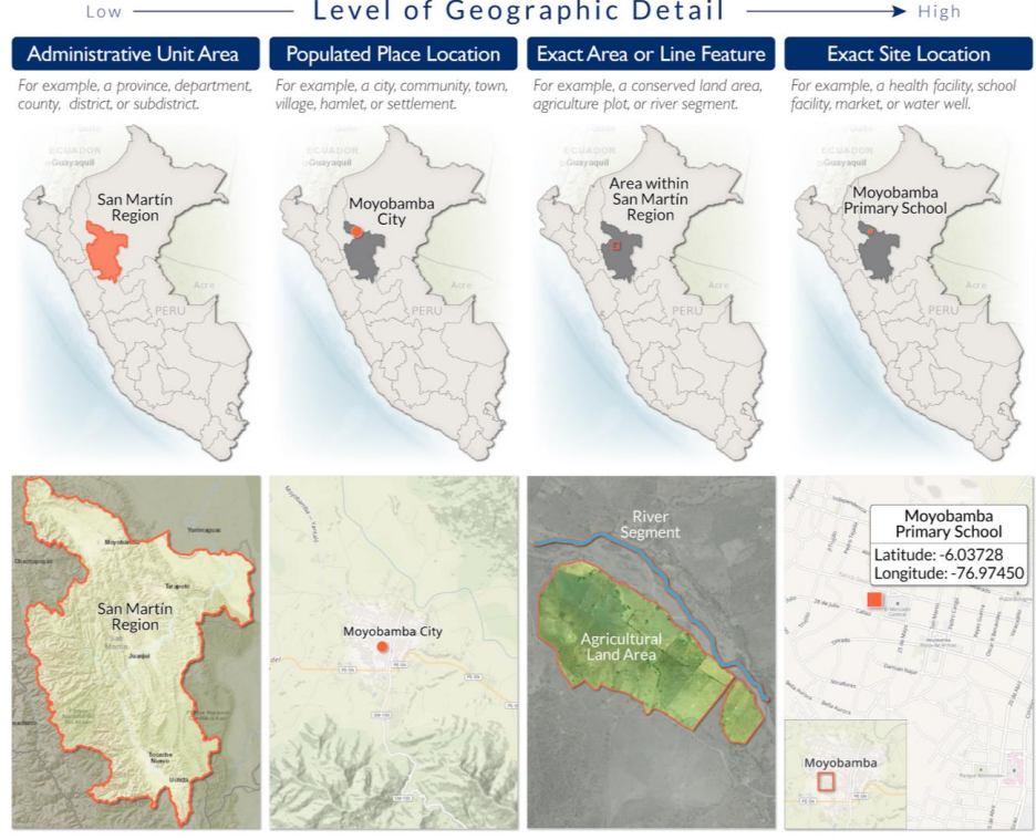
Activity Location Data include both an activity’s location of implementation and the location of intended beneficiaries. Both components of Activity Location Data must be collected by the IP at the Exact Site Location level. IPs must select the most applicable type of Exact Site Location from this list of options:
- Administrative Unit Area: the Administrative Unit in which the Activity takes place. In most cases, the IP would indicate the Municipality (identifying it by its official INE code) in which the activity occurred.
- Populated Place Location: the name of a populated place in which the Activity took place. USAID/Guatemala maintains an official list of populated places for IPs to reference to prevent ambiguous references.
- Exact Line or Area Feature: a recognizable feature such as a protected area boundary.
- Exact Site Location: may be either a recognizable feature such as a health site or school or geographic coordinates. USAID/Guatemala maintains an official list of schools and health sites for IPs to reference to prevent ambiguous references.
Location of implementation
If the activity is implemented in a location that is directly related to the development results generated by the activity, then collect the Exact Site Location or Exact Line or Area Feature. For example, if an Activity is located in a school to benefit the students or faculty of the school, collect the school name (Exact Site Location). If the Activity is located in a protected area and intended to benefit the ecosystem of that protected area, collect the name of the protected area (Exact Area Feature).
If the activity is implemented in a location that is not directly related to the development results generated by the activity, then collect the Populated Place Location. For example, if an Activity focused on policy reform to improve agricultural policy in the Western Highlands takes place in Guatemala City, record Guatemala City (Populated Place Location) since the development results are not related to the location of implementation.
We also recommend that IPs collect the latitude(s) and longitude(s) of the activity location or activity boundary whenever possible, except when doing so might reveal Personally Identifiable Information (e.g., do not collect the lat/lon of a household in a survey). Geographic coordinates can be used to help with disambiguation and confirm data quality.
Location of intended beneficiaries
The Location of Intended Beneficiaries must be collected, at a minimum, at the Department level (Administrative Unit 1). However, whenever possible we recommend collecting beneficiary location data at the Municipal level (Administrative Unit 2). Ideally, the Location of Intended Beneficiaries should be collected at the level of granularity necessary to support operational awareness and programmatic decision-making. When the activity benefits all residents of Guatemala, the Location of Intended Beneficiaries should be recorded as the country of Guatemala.
For example, consider an activity intended to build capacity for Municipality managers in the Department of Huehuetenango. The training is conducted in the city of Huehuetenango but benefits managers of Municipalities across the Department. In this case, the Department of Huehuetenango will represent the activity’s Location of Intended Beneficiaries. However, if only a few managers of the 31 Municipalities in Huehuetenango attend, the Municipalities of the attending managers will better represent the activity’s Location of Intended Beneficiaries.
Exemptions and waivers
Activity Location Data does not need to be collected under the following circumstances
- If the Activity was implemented prior to issuance of ADS579mab, some requirements are relaxed. Location of implementation must be reported at the Department (Admin1) level, but higher precision is preferred. Location of beneficiaries is not required.
- For worldwide or regional partnerships with Public International Organizations (PIOs) that qualify as Project Contributions or General Contributions pursuant to ADS 308.3.9, Types of PIO Agreements
- For Inter-Agency Agreements (IAAs) that support broad development objectives that are not tied to specific countries
- For Activities funded by multiple donors in which USAID does not have direct control over the countries of implementation
Waivers may be granted under extenuating circumstances if approved by the Mission Director and documented under an Action Memorandum for up to two years, which can be extended.
Submitting data to the DDL
The Development Data Library (DDL) is the Agency’s repository of USAID-funded, machine readable data created or collected by the Agency and its implementing partners. Datasets and supporting documentation created or collected directly by USAID/Guatemala or under USAID-funded awards must be submitted for inclusion in the DDL.
USAID staff, as well as contractors and recipients of USAID assistance awards (e.g., grants and cooperative agreements), must submit any dataset created or collected with USAID funding to the DDL in accordance with the terms and conditions of their awards.
Requirements for which datasets must be submitted to the DDL are defined broadly (see ADS 579.3.3.2) and include:
- Data that inform performance monitoring (excluding the indicator data itself, which will be reported through alternative means)
- Surveys, economic assessments, and organization capacity assessments
- Research data
- USAID Information System data (e.g., financial data)
Supporting documentation including codebooks, data dictionaries, data gathering tools (e.g., forms, survey instruments), explanations, data quality reviews, data collection methodologies, and other metadata must also be reported alongside the dataset.
USAID will not necessarily release to the public all data submitted to the DDL in its entirety, however data submitters are responsible for redacting any sensitive information, including personally identifiable information (PII). Redactions must fall under one of the “principled exceptions to the presumption in favor of openness” established in OMB Bulletin 12-01, “Guidance on Collection of U.S. Foreign Assistance Data.”
If the redaction process will remove information that would prove useful during secondary data analysis, USAID/Guatemala must work within prevailing best practices to identify alternative redaction methods or consider, with their GC or RLO point of contact, assigning an access level of “Restricted Public” to the Dataset.
Should USAID staff or implementing partners submit a Dataset to a publicly accessible research database, they are not required to submit the data to the DDL. However, they must submit a notice to the DDL, providing details on where and how to access the data.
The A/COR is responsible for reviewing Datasets prior to submission, which includes identifying principled exceptions to release, redacting (or ensuring the redaction of) sensitive information, and obtaining required clearances (see 579.3.2.5).
Managing data risk
USAID development data are collected, managed, and shared for an intended benefit, such as improved development decision making and accountability and transparency. However, USAID development data may also present some level of data risk in addition to benefit. Therefore, balancing benefit and risk is a key component of responsible data collection and management.
As mentioned above, data submitted to the DDL will not always be publicly available. Do not unnecessarily limit data collection or reporting due to potential data risk or overly redact or aggregated data before it is submitted to the DDL. Instead, consider restricting data as “Restricted Public” or “Non-Public”. IPs may propose the appropriate data access level and recommend how the data should be redacted or aggregated before it is shared when Activity Location Data or other Datasets present risk.
When data include PII, safeguarding procedures should be applied to protect PII from unauthorized access (see ADS 508, Privacy Program and Data Security Guidance: Protecting Beneficiaries). In addition, certain country contexts may present insecure environments that result in safety concerns regarding geographic data collection in the field. When applicable, these data collection constraints should also be considered when planning for data collection.
Collecting data at a high level of geographic detail often increases the benefit of collecting the data yet it may also increase the data risk in certain scenarios due to the detailed location information included in the data.
Data risk for geographic data should be evaluated at two stages:
- Planning for geographic data collection: consider if collecting data at the intended level of geographic detail will pose a substantial risk to beneficiaries or data collectors.
- Managing geographic data submitted to USAID: consider whether publicly releasing data at the current level of geographic detail will pose substantial risk.
ADS 579saa Geographic Data Collection and Submission Standards provides guidance for considering risk related specifically to geographic data, including strategies for mitigating data collection risk. The Monitoring Toolkit’s Data Security Guidance and the Considerations for Using Data Responsibly at USAID are also helpful resources.
Sharing data
The Agency encourages its partners, the academic and scientific communities, and the public at large to make broad use of USAID data for innovative scientific, technological, analytical, and other applications. The DDL is the primary source of shareable data, however Guatemala may also make available internal data management systems to IPs. This will increase the use of data by IPs, ensure data used by IPs is appropriate, and reduce duplication of efforts in data acquisition and cleaning.
Relevant policies and initiatives
The Foundations for Evidence-Based Policymaking Act of 2018 (Evidence Act) and subsequent Office of Management and Budget (OMB) Memoranda M-19-18 and M-19-23 lay the foundation for improving data collection and use in the federal government.
The draft USAID Geospatial Strategy (in draft) will guide the Agency’s strategy for collection and use of geospatial data specifically.
ADS 579 USAID Development Data requires that all data collected or acquired by implementing partners is submitted to USAID. This is included as mandatory provisions in all awards, for example, see the language in ADS 302mas (see page 7).
ADS 579mab Activity Location Data requires that all USAID OUs collect activity location data and this is most commonly done by including relevant requirements in solicitation/award language.
ADS 579saa Geographic Data Collection and Submission Standards provides data collection and submission standards for geographic data to be used in implementing the geographic data collection and submission requirements outlined above.
ADS 201 Operational Policy for the Program Cycle recommends disaggregating performance and context indicators by geographic location and there is an Additional Help document that provides implementation guidance.
Proposed revisions to the AIDAR will increase the importance of and requirements for Data Management Plans (DMPs) and Activity Monitoring, Evaluation and Learning Plans (AMELPs).
The rollout of the Development Information System (DIS) and proposed combination of the Development Experience Clearinghouse (DEC) and Development Data Library (DDL) into a single Digital Front Door (DFD) for the Agency will also affect this proposal.